 |
Welcome | The Projects | Events | News | About Us | Documents | Contact Us
Conceptual
Development
Plan
The plan has included an intensive review and study of many previous plans that have been conducted in Yonkers. Many of these plans have contributed to the ideas and principles included in this Plan, however this is the first comprehensive effort that ties the many different districts together with a larger vision for the future of Yonkers.
SFC is a partnership between Millburn, NJ-based Fidelco Realty Group and Valhalla, New York's Cappelli Enterprises. The two development firms joined with the City of Yonkers in a public-private partnership to revitalize the Southwest section of the city. Both companies bring an abundance of experience, expertise and leadership in urban redevelopment, making them ideal partners in helping build Yonkers' future.
Ehrenkrantz Eckstut & Kuhn Architects, an internationally-renowned firm that has distinguished itself by creating great places, has served as the architect for the Plan. EE&K's multi-faceted expertise and history working in Yonkers uniquely positions it to understand the myriad of conditions necessary to develop a Conceptual Plan.
The Plan has been developed around a framework that integrates three key elements into each district's proposal: Development, Open Space and Transportation. Integral to the underlying concepts of the proposal is the balance between Development and Open Space, the belief that both work best together rather than in isolation, and the understanding that successful places enjoy convenient and comfortable access through roadways and transit options.
Development
Located in the southwestern corner of Westchester County, the City of Yonkers can trace its origins to the mid-seventeenth century. Historically, the presence of two major natural transportation corridors, the Hudson River and the Saw Mill River Valley, established the western part of Yonkers as an early focal point for settlement. Yonkers' geographic position, especially its proximity to New York City, has been of fundamental importance throughout its history. Serving as a major transportation corridor between New York City and northern New York State, the City profited favorably from the trade and commerce that flowed through its borders.
In recent times Yonkers has seen the early signs of a renaissance. Projects such as Hudson Park, Station Plaza, and the Yonkers Riverfront Library have brought both public and private uses back to the downtown. The relationship between this development and the early phases of the Yonkers Esplanade demonstrate that high density development balanced with open spaces create successful urban places.
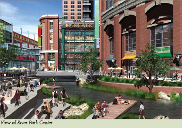
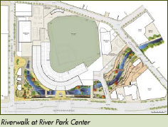
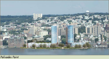
This renaissance continues with SFC's Phase I River Park Center, Cacace Center and Palisades Point, which will, respectively, create a vibrant urban downtown, consolidate the city's government center, and develop an iconic image for Yonkers on its waterfront.
The Plan recommends dense mixed use development balanced with open space to maintain an appropriate scale for street level experiences. It is with this density that the many different retail, entertainment, arts, cultural, and public space amenities can be realized.
The Plan recognizes economic development as critical to the future health of the City, recommending strengthening the Nepperhan Valley as an industrial center. To support the continuing growth of Yonkers' industrial sector, expansions in education options need to be developed. The Plan suggests the location of a State University of New York School of Technology in Yonkers to develop the next generation of skilled labor, as well as to provide continuing education opportunities to the existing workforce.
Open Space
The City of Yonkers currently has a park system that includes over 40 parks, and is home to sections of various regional trail systems that connect open spaces throughout the area.
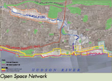
The Saw Mill River, historically an economic engine of the city, has been covered in sections or is not publicly accessible where it remains open. The Plan recommends the opening of the river in areas, as well as landscaping and enhancement of the river where it is currently open.
The Hudson Waterfront is both a golden opportunity for the City to provide a world class amenity to its residents, as well as a rare chance for a city to change its reputation. The Plan recommends a continuous public Esplanade along the Hudson River throughout the designation area, providing public access, maritime recreation, and different experiences along the waterfront. Development along the Waterfront will be centered around a series of public "places" that will provide balance between development and open space, and replace the current industrial dominated waterfront with a residential community. Open spaces are places where people most often experience public art. The Plan recommends the formation of a Public Art Commission, and funding opportunities to expand art both to strengthen the community and also to serve as attractions that further stimulate the local economy.
Transportation
Getting to and from Yonkers is important for the success of the Plan. Urban centers offer numerous modes of transportation, connecting regional, local, neighborhood, and individual systems to create an integrated network that allows people to travel conveniently and efficiently. Such transportation can take more traditional forms of cars and buses, as well as more location specific forms like boats and trains. The people of Yonkers enjoy all of these options, and this Plan works to ensure they are connected and utilized to their fullest potential.
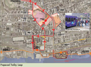
Yonkers enjoys great access to the Metro North rail line, several local Parkways, the Interstate Highway system, and the Hudson River, all important transportation connections. Access via Mass Transit is essential, and it is important to ensure connections between transit options. The Plan recommends a Yonkers Trolley Loop, utilizing a motorized trolley system, and connecting downtown Yonkers and the Waterfront.
The Plan recommends improving Yonkers and Nepperhan Avenues as the major access corridors to the city from the East, connecting traffic from the regional parkway and highway systems to downtown Yonkers. To accommodate additional development as well as to ensure the opportunity for all citizens of Yonkers to enjoy new public spaces and amenities, public parking that is convenient and easily accessible is essential.
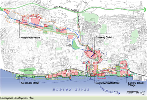
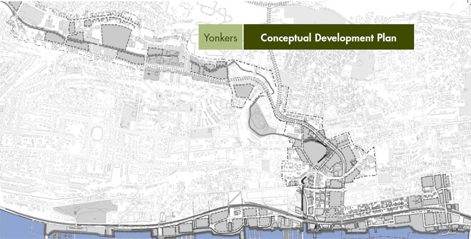
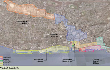
Districts
Yonkers is a city of neighborhoods that vary in character as much as they do in topography. The Plan defines five different districts, resulting from the areas specified in the MDDA. Each of these five districts have distinctive characteristics and thus hold unique opportunities. The Plan links these disparate districts together by proposing an integrated approach to threading together Open Space and Transportation elements through each district. This allows Development to take different forms while maintaining an over arching identity for the future of Yonkers. The plan focuses on a balanced approach between development and open space, under the premise that neither works as well without a critical amount of the other.
Gateway District
The Gateway District will emerge as a vibrant 24-hour downtown. A consolidated Government Center and an expanded market for office space will create busy street life during the days, while new residential development, and retail and entertainment destinations - centered around River Park Center and a new ballpark - will keep the district alive well into the evenings. Major features of the district will be the daylighting and landscaping of the Saw Mill River, and improving Nepperhan Avenue as the major vehicular access into Southwest Yonkers.
Downtown/Waterfront District
The Downtown/Waterfront District is the connection between the Gateway District to the Hudson River. The district will continue the current revitalization of the Hudson Waterfront, building new mixed use developments and public open spaces on the rivers edge. The new waterfront development will establish an iconic image for Yonkers, while the continuous Esplanade gives the historically privately owned waterfront to the public. The district also serves as a major transit access point, and now will have a great arrival point at Larkin Plaza, which will be a new public park featuring the daylighting and landscaping of the Saw Mill River and mixed use development lining the park.
Ludlow Transit Village District
The Ludlow Transit Village will become a high density mixed use area centered around the Ludlow Train Station. Ludlow Street will be the new "Main Street" for the surrounding neighborhoods, and will connect Riverdale Avenue to the Waterfront. The district will extend the public waterfront south, and create a new public park on the waterfront. A vibrant waterfront with retail pavilions and a new marina will create an intimate "neighborhood" feel.
Alexander Street District
The Alexander Street District will be a new neighborhood with mixed use development within walking distance to the Yonkers and Glenwood Train Stations. Alexander Street expands the public waterfront Esplanade north to the JFK Marina, and establishes a continuous waterfront roadway system that links over two miles of the Hudson Riverfront for vehicular traffic. High density development along the waterfront is positioned around public open spaces that have different characters, and are inviting to the public.
Nepperhan Valley District
The Nepperhan Valley District will capitalize on its industrial heritage and proximity to local highways. The district will have three distinct areas: North, Central and South. The North Nepperhan area will offer opportunities for relocating industry from the waterfront; Central Nepperhan will adaptively reuse the former Alexander Smith Carpet Mills into a live/work loft environment; South Nepperhan will build upon the Valley Technology Center to offer development opportunity for office space close to downtown. Landscaping and improving the Saw Mill River, where possible, will link the Nepperhan Valley District to the other districts, maintaining connections to water and open space as a defining feature of the entire city.